
iMapBuilder - Interactive Map Software
![]()
![]()
Help Topics:
Getting Started
- Installation guide
- Interface Introduction
- Create an interactive map
- Map properties
- Styles and color theme
- Tooltip
Draw on map
- Add marker
- Draw line
- Draw route
- Add label
- Add clickable area
- Insert image or add logo
- Edit multiple objects
Software Features
- Area color and link settings
- Create heat map
- Map with legend
- Category filter for markers
- Highlight and group areas
- Import city to an interactive map
- Pan and zoom function
- Default zoom level and center point
- Batch edit region settings
Publish to the web
Embed map into blog or CMS
Plot latitude and longitude
Example of use
- Create population density heat map
- Clickable image map
- Create a drill down map
- Create World map
- Create U.S. map
License and registration
Plot locations on map using latitude and longitude
iMapBuilder supports to add marker using latitude and longitude coordinates,
which is suitable for pinpointing city locations, displaying branch offices across
the regions, or showing an absolute location of a particular place. The software
allows you to add pins through the data grid, or import from an Excel spreadsheet
file.
- Select File > New in the toolbar. Click latitude and longitude map in start wizard, a list of maps would be displayed such as World countries and United States (Geo).
- To add icon, you can click on the bulk input/ import data button and select markers under points and lines section.
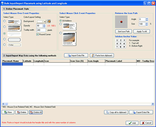
- You are required to assign the default type of mouseover/ mouse
click event properties, this setting will apply to all the imported points. In
section 1, select the tooltips styles, set the color/ width. After that, select
mouse click event properties and choose the map icons. Fill in the information
of marker using Grid in section 2 as below:
Importing data from an Excel spreadsheet file
You can import your data from a spreadsheet Unicode text file (.txt) by pressing import data file or click paste from clipboard button to paste the data from clipboard.
Click import data file, load a data file in TXT format, select a recent datafile or load a sample data.

Column Description Sample Marker name A reference name shown in the item list. Washington DC Latitude The latitude coordinate of the label in decimal degree format, range from 90 to -90 where N is positive and S is negative. 38.89 Longitude The longitude coordinate of the label in decimal degree format, range from -180 to 180 where W is negative and E is positive. -77.02 Icon Marker icon, click get icon path in section 2 to retrieve the icon path, then paste into this field. Or click apply to all to fill in the icon size and angle. icons/standard/dot_red.swf Icon Size Icon size in percentage, ranges from integer 1 to 300. 100 Icon Angle The angle of rotation of the marker icon, ranges from integer -180 to 180. 30 Marker label The text label besides the marker.
Washington DC MO - Tooltip Description The description text for mouseover tooltip. The branch office is located here. MO - InfoBox Description The description text for the mouseover infobox. Contact person: John Smith MO - InfoBox Image The image path for the mouseover infobox. Only local path is supported. C:\Documents and Settings\image.gif MO - InfoBox Anchor The anchor position of the mouseover infobox

1 MC - Url The URL address to open when clicking the marker. http://www.example.com MC - Url Target The target to open the URL Address, for example, _blank for new window, _self for same window. _blank MC - InfoBox Description The description text for the mouse click infobox, leave it blank if URL type is selected The branch office is located here. MC - InfoBox Image The image path for the mouse click infobox. MC - InfoBox Anchor The anchor position of the mouse click infobox
9
Convert latitude and longitude coordinates to x/ y coordinates
In case you may need to connect your database and generate the XML on the fly, you may need to convert the lat/ long coordinates to x/ y coordinates, because our XML will only support x/y coordinates.
You may use the following formulas:For World Countries Map:
X = (((180+Long)*800)/360);
Y = (((90-Lat)*400.25)/180) - 14.25;
For United States Mainland (GEO) Map:
X = (((Long-(-124.73174))/(-66.94-(-124.73174))*800));
Y = (((Lat-49.384358)/24.544701-49.384358)344));
For United States (GEO) Map:
if Long - (-187.538333) < 0 then
{
Long = Long + 360
}
else if Long - (-187.538333) > 360 then
{
Long = Long - 360;
};
X = (((Long-(-187.538333))/(-65.22111-(-187.538333))*800));Y = (((Lat-71.352560644)/(17.884813-71.352560644)*350));